Sands of time: Photos through ages show dunes changes
To most Americans, a sand dune conjures up an image of an exotic place somewhere far, far away. But Michiganders don’t have to travel far, with the world’s largest body of freshwater coastal dunes in their backyard.
These unique Michigan landmarks began forming around 5,000 years ago and have evolved in complex ways since that time. While scientists generally understand the overall chronology of dune formation, there is a continued need to better understand how the dunes have changed in the historic period.
Our most recent project, “Learning to Live in Dynamic Dunes,” built an archive of historic coastal sand dune photographs at many points along Lake Michigan. This database is allowing researchers to better understand and predict the morphology, movement, and characteristics of dunes. This information is crucial for long-term preservation, conservation, and management activities within coastal areas.
For this project, Michigan State University Professor Alan Arbogast and his research assistant Kevin McKeehan, collected a cache of over 200 historical photos from various state and private archives along with contributions from citizen scientists in the general public. A subset of these historical photos was then paired with exact modern replicates to create a coastal dunes repeat photography map.
Southwest Michigan
Grand Beach
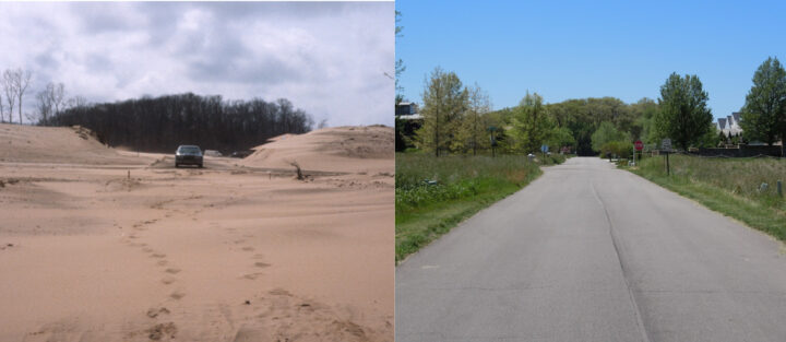
At the southern tip of Michigan’s Lower Peninsula, south of New Buffalo, are dunes south running through the community of Grand Beach. Since 1987, when the original photographs were taken of this site by EGLE, development has flattened some of the dunes here and vegetation has grown where homes were not built. These two forces, especially the expansion of vegetation, are seen in nearly all our repeat photography sites along the Lake Michigan shoreline. This particular photograph in 1987 captures a portion of a parabolic dune known as Eiffel Tower Dune.
LAT: 41.782578, LON: -86.778755
New Buffalo
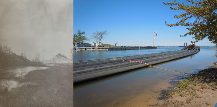
This photograph is of Lighthouse Dune, which once stood near the mouth of the Galien River where New Buffalo’s harbor now sits. The year of the original photograph is approximately 1902. This dune may have undermined a lighthouse on this spot due to dune activity prior to the photograph.
LAT: 41.800086, LON: -86.748155
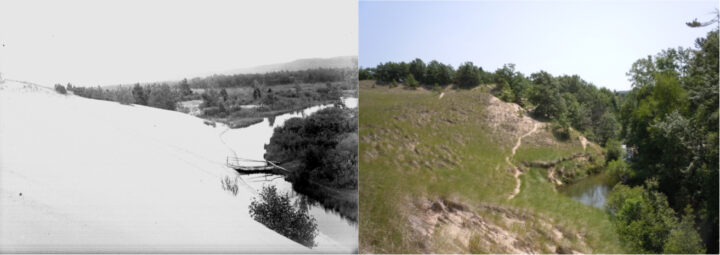
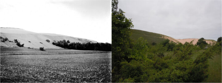
Warren Dunes at Painterville Drain
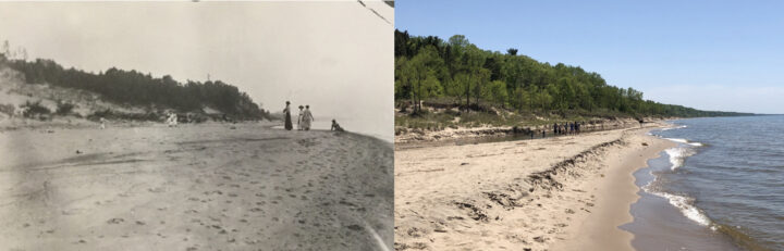
These photographs are of Warren Dunes, where Painterville Drain attempts to enter Lake Michigan. The slopes of the dunes above the creek on the left show an expansion of grasses and tress over the last 119 years.
LAT: 41.904067, LON: -86.610062
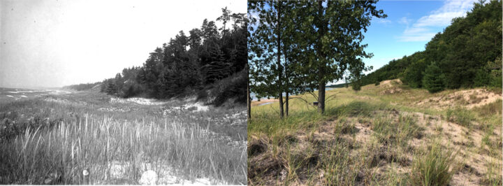
Warren Dunes
These photographs are looking WNW from the dunes in the vicinity of the south parking lot at Warren Dunes State Park. Since the original photograph was taken in 1946, grasses have stabilized what was a dune of bare sand in the foreground and another dune in the mid-ground. Both dunes subsequently have changed shape somewhat as they stabilized, which is not unusual.
LAT: 41.903323, LON: -86.603600
West Michigan
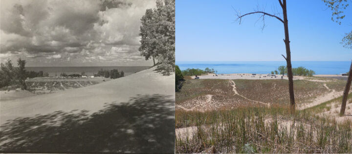
Oval Beach
The original photograph is a postcard from 1947. The 2019 photograph from the same location shows how vegetation expansion can affect the landscape. As vegetation expanded over the bluff and stabilized it, the vegetation traps additional sand, which likely led to the aggradation and expansion lakeward of the bluff.
LAT: 42.662274, LON: -86.216413
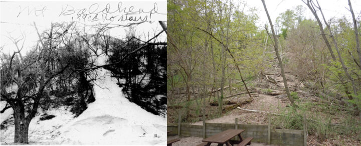
Mount Baldhead base
Historical photographs from Mt. Baldhead near Saugatuck show the large dune once was indeed “bald” with large amounts of bare sand atop its “head”. This original photograph from 1890 is no different. While trees populate the dune’s base at that time, the top of the dune is bare sand. The 2019 photograph from the same location and approximately the same time of year shows that woody vegetation at the base and slopes has become denser while the top of Mt. Baldhead is no longer bald.
LAT: 42.661227, LON: -86.207821
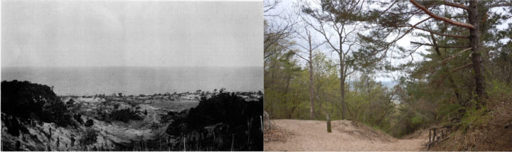
Mount Baldhead Crest
Historical photographs from Mt. Baldhead near Saugatuck show the large dune once was indeed “bald” with large amounts of bare sand atop its “head”. This original photograph from 1900 is no different. While the crest cannot be seen, a view from the top of Mt. Baldhead in 1900 afforded one a clear path to Lake Michigan, with a mixture of trees, woody bushes, grasses and bare sand amongst the dunes below the crest. The 2019 photograph from the same location just below the crest on the trail to Lake Michigan affords no such view. The waters of Lake Michigan can be seen only through a tunnel of mature vegetation.
LAT: 42.661112, LON: -86.209296
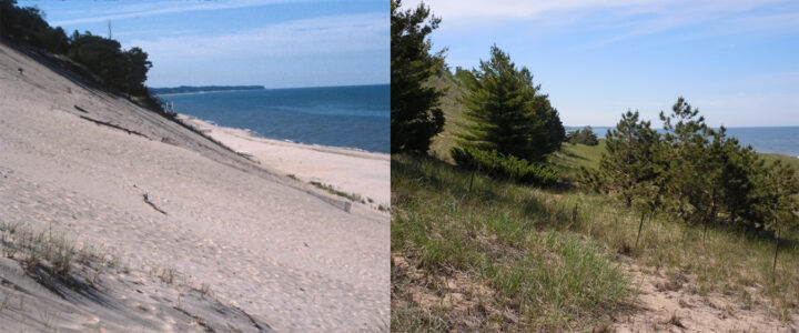
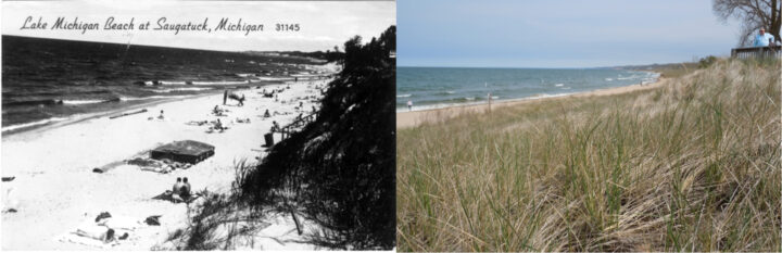
Laketown Beach
In a relatively short 30-year interval, a steep, bare sand dune face at Laketown Beach has been stabilized by vegetation, which has expanded significantly since the original photograph was taken. Not only grasses have expanded, but also woody vegetation and trees. At the time of the 2019 photograph, the threatened Pitcher’s Thistle (Cirsium pitcheri) was also seen nearby.
LAT: 42.724575, LON: -86.20641
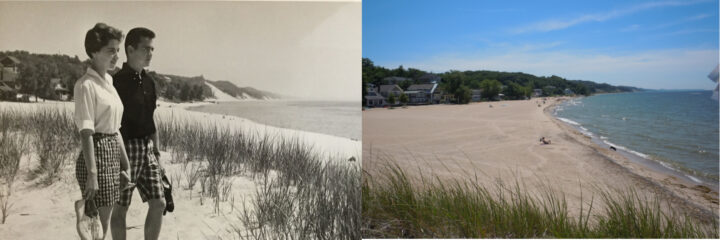
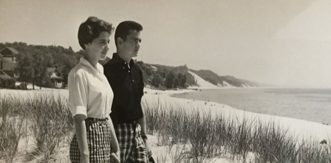
Macatawa Beach
This photo pair shares some characteristics from photo pair for Holland State Park just north of the Big Red Lighthouse. The historical Holland State Park photograph was taken in 1958, while this original photograph was taken just four years later and about ½ mile south as part of a tourism campaign. And like the 1958 Holland State Park photograph, in the distance of this 1962 photograph from Macatawa Beach, there are bare sand dune bluffs in the distance that by 2019 have been covered by vegetation. Here, there is also a sand dune on which the couple are standing that by 2019 is thick with grasses. Most of this grassy dune is behind the photographer in 2019, but it is impressive the amount of vegetation there now. Both locations also show the unmistakable hands of human development as well.
LAT: 42.771723, LON: -86.210435
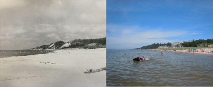
Holland State Park
This photo pair shares some characteristics from photo pair for Macatawa Beach just south of the Big Red Lighthouse. The historical Macatawa Beach photograph was taken in 1962, while this original photograph was taken just four years earlier. And like the 1962 Macatawa Beach photograph, in the distance of this 1958 photograph from Holland State Beach, there are bare sand dune bluffs in the distance that by 2019 have been covered by vegetation. Both locations also show the unmistakable hands of human development as well. The repeat photograph for this location by 2019 had to be taken 30 feet into Lake Michigan due to high lake levels.
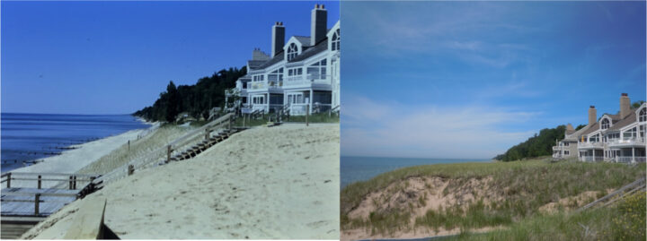
Ottawa Beach
These photographs are taken about 1800 ft north-northeast of the Holland State Park photographs. At the time of the original 1987 photograph, a planting effort was underway to stabilize the dune at the foot of a new housing development. By 2019, the vegetation had expanded, either through maintenance efforts or due to other factors. There has also been a lot of geomorphic changes in the dunes. The expansion of grasses had caused the dune to aggrade upward and outward toward Lake Michigan, a phenomenon seen in other 2019 photographs as well. This occurs due to vegetation’s known ability to trap airborne particles and saltating sand. This phenomenon also makes it difficult to conduct repeat photography, as the 2019 photo location is at least a two feet higher than in 1987.
LAT: 42.78062, LON: -86.210398
Grand Haven
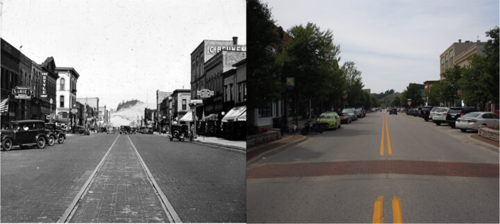
These photographs are taken down Grand Haven’s Washington Street between Second and Third streets. In the distance, beyond downtown and across the Grand River, is Kitchel Dune. In 1935, bare sand was abundant across much of the dune, but by the summer of 2019, vegetation has expanded across all of Kitchel Dune.
LAT: 43.063741, LON: -86.230219
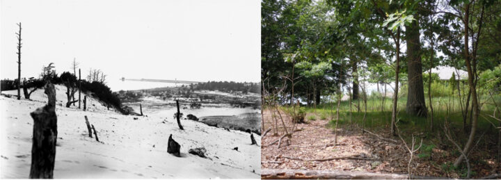
Muskegon Channel
The original photograph was taken in 1915 from a dune southeast of the entrance to the Muskegon Channel. A ghost forest amid bare sand populate the dune crest. By 2019, the entire dune has been overrun by woody vegetation and home construction. Through the trees in 2019, one can see the breakwater and lights for the channel, albeit barely.
LAT: 43.220897, LON: -86.330887
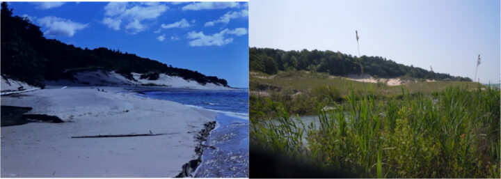
Meinert Park
There are two photograph pairs from the Meinert Park area of Muskegon County. While the two pairs are from different spots with the coastal park, both show a considerable amount of change since the original photographs were captured in 1987. Vegetation has expanded, Little Flower Creek has changed its path, and the Lake Michigan shoreline is farther west in 2019. This is not to suggest that lake levels have fallen, but instead it appears large, vegetated, stable shoreline foredunes have formed in the last 30 years where the shore once was located.
LAT: 43.458357, LON: -86.45728
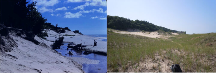
Meinert Park
There are two photograph pairs from the Meinert Park area of Muskegon County. While the two pairs are from different spots with the coastal park, both show a considerable amount of change since the original photographs were captured in 1987. Vegetation has expanded, Little Flower Creek has changed its path, and the Lake Michigan shoreline is farther west in 2019. This is not to suggest that lake levels have fallen, but instead it appears large, vegetated, stable shoreline foredunes have formed in the last 30 years where the shore once was located.
LAT: 43.457661, LON: -86.456837
Silver Creek
This photograph pair is from a location at the southern end of Silver Lake State Park on the north bank of Silver Creek. This spot is west of the Ruckel’s Bridge area and west of a water control structure, which in 2019 photograph is obscured behind the trees. In the 100+ years since the original photograph, a large area of bare sand dunes has been transformed by the expansion of grasses and trees. Another photograph looking west instead of east shows a similar expansion of vegetation, but was not included here because the 2019 photograph is obscured by dense trees and underbrush.
LAT: 43.657587, LON: -86.529723
Northwest
Pentwater
This photograph pair is from a location on the Lake Michigan Camp and Retreat property, the operators of which kindly allowed access for our research. While the 1915 photograph shows vegetated backshore and foredune areas, possibly from a planting program, the 2019 shows the addition of woody vegetation on the lower dune landscape. This suggests the foredunes in the foreground and midground of the 2019 photograph may become stabilized in a manner similar to the second dune area on the right that has been stabilized by trees since at least 1915.
LAT: 43.757009, LON: -86.453706
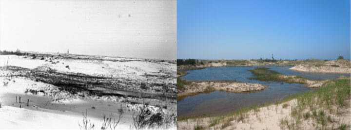
Big Sable Point
This photograph pair is of Big Sable Point and Lighthouse, the latter with its distinctive black and white stripes. The 2019 photograph shows a somewhat transformed landscape, with less bare sand, more grasses, and much more water, possibly seeping from Lake Michigan, which is approximately 1,600 feet to the west. The modern dunes also appear larger and taller than in 1915. The research team would like to thank the staff at Ludington State Park for their assistance in recapturing this photograph.
LAT: 44.062615, LON: -86.509579
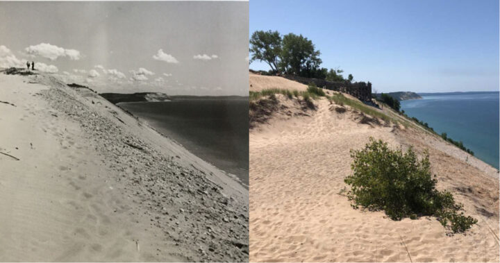
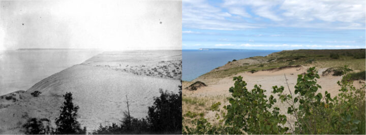
Sleeping Bear Overlook
This photograph pair was taken north of the modern observation platform at the Sleeping Bear Overlook. The platform was not present when the original 1964 photograph was taken. While much of this area remains bare sand atop ancient lake sediment, the 2019 photograph shows an advance of some grasses and especially woody vegetation. The research team would like to thank the staff at Sleeping Bear Dunes National Lakeshore for their assistance in recapturing this photograph.
LAT: 44.859808, LON: -86.06717
Sleeping Bear Dunes
The original 1907 photograph was taken looking north toward South Manitou Island from the western flank of the vegetated dune feature known as The Sleeping Bear. Since that time, The Sleeping Bear has undergone changes, migrating inland and eroding in places. One place where erosion has taken place is the western slope where the original photograph was taken. Thus, the re-photograph was taken just east on the remaining slope. In the 2019 photograph, the dune field beyond to the north exhibits the same trend seen elsewhere in our study – an expansion of vegetation across much of the area – although patches of bare sand in the foreground exist. The research team would like to thank the staff at Sleeping Bear Dunes National Lakeshore for their assistance in recapturing this photograph.
LAT: 44.874237, LON: -86.069461
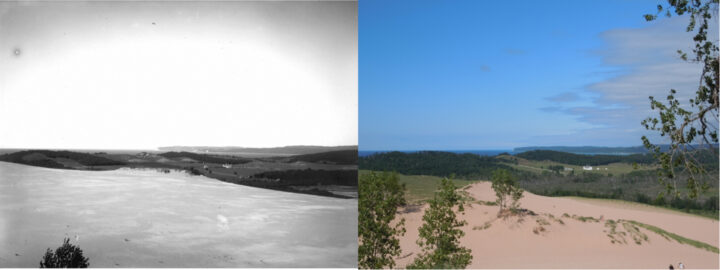
Sleeping Bear Dunes climb
The Dune Climb at Sleeping Bear Dunes National Lakeshore is one of the iconic places in Michigan. Many residents and tourists to the park trundle up the side of this bare sand dune slipface in what some see at a Michigan bucket list experience. Despite a well-worn pathway up the Dune Climb, much of the dune slipface, crest, cornice, and flank in 2019 is covered with grasses. A comparison of the 2019 photograph to the 1917 image shows the Dune Climb area was almost exclusively bare sand except for an agricultural field and a forested area at the dune’s toe.
The research team would like to thank the staff at Sleeping Bear Dunes National Lakeshore for their assistance in recapturing this photograph.
LAT: 44.880368, LON: -86.042494
Sleeping Bear Dunes Day Farm
The Dune Climb at Sleeping Bear Dunes National Lakeshore is one of the iconic places in Michigan. Many residents and tourists to the park trundle up the side of this bare sand dune slipface in what some see at a Michigan bucket list experience. At the crest of the Dune Climb from the parking lot, the pathway splits. If one follows the southern fork through bare sand and up the side of a larger dune, one will find a bench with a commanding view of the area to the northeast. This area includes the Day Farm and the far bluffs of Pyramid Point. The lowlands surrounding the Day Farm are not dunes and have been farmlands and pasturelands for some time, including in 1918, when the original photograph in this pair was taken. What is notable in the 1918 photograph is the extent of bare sand atop the Dune Climb from the crest to the east toward Lake Michigan to the west. The area west of the crest also appears to be relatively flat. By 2019, the shape of the land has changed and vegetation is extensive in the direction of Lake Michigan behind a second dune crest where bare sand once predominated. There are additional trees as well.
The research team would like to thank the staff at Sleeping Bear Dunes National Lakeshore for their assistance in recapturing this photograph.
LAT: 44.881866, LON: -86.048518
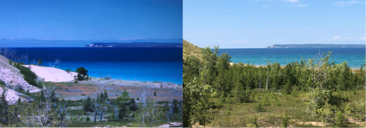
Sleeping Bear Point
This original photograph from approximately 1987 was submitted by one of our citizen scientists – Grace Dickinson Johnson of the Dickinson Photo Gallery on Glen Lake. The original photograph was taken from a sand dune looking north toward the vicinity of Sleeping Bear Point and across the Manitou Passage to North Manitou Island. In the earlier photograph, the area closest to the point is marked with bare sand and in the swales in the foreground the vegetation is mostly grasses with some shrubs and trees. By 2019, however, trees have overtaken some of the swales and grasses have expanded over the bare sand dunes on the left.
The research team would like to thank the staff at Sleeping Bear Dunes National Lakeshore for their assistance in recapturing this photograph.
LAT: 44.911859, LON: -86.039546
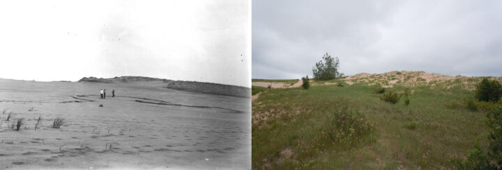
Sleeping Bear Point Trail
This photograph was taken near the Sleeping Bear Point Trail. In the original 1915 photograph, scientists from the University of Chicago study what appears to be a buried soil amid a sea of sand and an occasional blade of grass. By 2019, grasses, shrubs, and some trees have colonized and expanded over much of this area, except the trail itself.
The research team would like to thank the staff at Sleeping Bear Dunes National Lakeshore for their assistance in recapturing this photograph.
LAT: 44.911859, LON: -86.039546
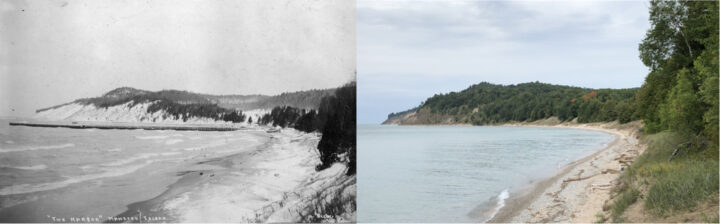
North Manitou Island
This photograph pair is of the west shore of North Manitou Island, specifically south of the Crescent Dock area. At the time of the original photograph, in approximately 1905, bare sand is noticeable along the dune slipfaces of the bluffs across the bay and among the foredunes up the shore. By 2019, grasses and trees have expanded across all of these areas with the exception of the rocky beach.
The research team would like to thank the staff at Sleeping Bear Dunes National Lakeshore for their assistance in recapturing this photograph. In particular, we’d like to thank Capt. David Schoeder and the Nahma for transportation across the Manitou Passage to the island.
Discover


Power environmental change today.
Your gift to the Michigan Environmental Council is a powerful investment in the air we breathe, our water and the places we love.
Sign up for environmental news & stories.
"*" indicates required fields